Sunday, November 20, 2011

Spence Ridge Trail Linville Gorge 11/5/2011

This trail is on the east side of the Linville Gorge accessed from the road leading from Gingercake Acres to Table Rock.  This is a much gentler but longer trail then the ones on the other side of the gorge.  The trail starts out almost level on an old road.  Don't be fooled though.  It is downhill all of the two miles to the Linville river which means uphill all the way back.   The backside of Hawksbill can be seen along this first section.


 After a short easy walk there is a sharp right turn at the only intersection we passed until we reached the river.  The trail begins to descend more quickly.  The leaves were wet and slick on the trail.  I was wishing I had remembered gloves as the morning was cold but the sun warmed us up about half way down.

We passed a spring that seemed to be right in the trail then began to follow a tiny run.  It became bigger as more springs and runs joined in until it was quite pretty.  There are several switchbacks as the trail drops lower into the gorge area.  We passed a couple of nice primitive campsites.  It is a pleasant descent till a short steep section right at the river

This trail reaches the river at the only footbridge in the Linville Wilderness area.  This spot is also known as house rock.  The trail that follows the river is on the other side of the bridge.  If you use one of the other trails on this side you must ford the river to access it.  The bridge is narrow but it is solid with a good handrail.

When we reached the bridge instead of crossing immediately we scrambled about 100 feet upstream on the rocks to a large rock with a pretty whitewater view.  This proved to be a sunny and warm but somewhat windy spot to have our picnic lunch.  While we ate several groups arrived at the bridge and all stopped to take pictures.


After lunch we crossed the bridge and followed the main gorge trail about a half mile downstream.  The trail immediately climbs above the river and stays where you can see the water but not easily access it.  This trail is technically more difficult being narrow and with many obstacles such as fallen trees.  This one rockfall beside the trail looked almost like a man made shelter.

We turned back and headed uphill fairly early because we knew getting out would be harder then coming in  This would probably make a good family hike to the river and the bridge but I would hesitate to take young children on the trail along the river.  The creek and rock formations along the way would be enjoyable for children and of course they would enjoy the long log bridge.

Sunday, October 23, 2011

Price Lake Loop 10/15/2011

We wanted to enjoy the Fall color along the Blue Ridge Parkway while including a relaxed walk so we headed for Price Lake.  Starting the 2.3 mile loop from the overlook parking we headed counterclockwise.  The trail stays close to the parkway passing a small fishing platform, a section of the campground, the amphitheater, and the boat rental area with additional parking.

At this point the trail moves deeper into the woods with several bridges crossing the creeks feeding the lake.  The water was clear but we didn't see any minnows at this time of year.  There was much evidence of beaver activity both old and recent.  The lake is in clear view along most of the trail.  The trail on this side was mostly level with only a little mud.

This trail was busy today with family groups enjoying the views, picnicing, and fishing.  We have hiked here at other times of year and seen far fewer people.  It was still a peaceful walk with  many ins and outs of coves so that the trail did not feel crowded.  On the back side we came to one area that was quite wet from the rains this week.  This area is not normally this wet.

The last portion of the trail stayed really close to the lake with good views.  There were a couple of spots where we had to watch our footing as the trail crosses rocks sloping down to the river.  This is an easy trail but not obstacle free.  It is a fun trail for children.  The trail leaves the woods right beside the parking and across from the dam. 

Friday, October 14, 2011

De Hart Botanical Gardens 10/9/2011

The Grandsons, Matthew and Daniel, joined us for a walk around the Franklin County Nature Preserve of the De Hart Botanical Gardens south of Louisberg, NC.  The trail map that we picked up at the gazebo by the small gravel parking lot stated that there were 1.8 miles of hiking trails in each side of the preserve.  The trails  for the two sides meet only at the parking area.

We walked the area to the right first.  This section has  plants that have been brought here from other parts of North Carolina.  The trail leads up a small hill past some rocks to an overlook of the lake.  There were several varieties of flowers blooming.  Judging from the azalea bushes and the mention of other flowers including wildpink and Crane Fly Orchids this must be a beautiful place in the Spring.

Beyond the overlook the trail goes down to the lake and crosses on a footbridge.  The boys spotted Bass, Brim, minnows, and turtles in the lake.  We followed a loop trail through the woods and up the hill on the other side of the lake before finishing the loop around the small lake.  The last section of the trail led us through a stand of bamboo and back to the parking area.

We crossed the parking area and took the Waterfall trail.  This side of the preserve remains a natural habitat.  The trail is a loop except for a short section at the beginning.  We were disappointed to find the waterfall  almost completely dry.   On a short side trail to a historic home site I spotted this  log that looked like a alligator to me.  What do you see?

Beyond the short detour we passed a smaller lake.  This one is much more natural then the one on the other side of the preserve.  A frog jumped in the water from the bank as I approached.  The trail continues around and follows powerlines back to the beginning of the loop.  This whole area is peaceful with easy well maintained trails.

Tuesday, October 4, 2011

Bass Lake and Trout Lake Loop 9/24/11

We had planned a day of hiking on the Tanawha trail but after the clouds rolled in we decided on lunch in Blowing Rock and walks around two lakes.  The first lake is the one that you see from the Moses Cone Manor.  There is parking for the lake off of 221 between Blowing Rock and the parkway.  The trails connect from here to the manor but today we just walked the lake loop.

This  trail is wide and mostly level.  There were lots of water lilies around the edges.  Ducks were scattered around in the lily pads and near the island in the lake.   A number of people were fishing from the banks.  The loop is a total of .8 miles and appears to be popular for walking dogs and exercise walking.  For most of the walk you have a clear view of the lake.


From here we followed 221 to where it met the parkway.  Instead of entering the parkway we crossed it and turned right.  Just past this point was an access road for the Trout Lake parking area.  The 1 mile loop around this lake has a different feel from Bass Lake.  Although still mostly level this trail is more natural and there  were trees blocking the open views of the lake for much of the walk.

Turning left from the parking the trail follows the stream that supplies the lake for a time until reaching a foot bridge allowing us to cross and return to the lake.  At the far end of the hike the trail follows the entrance road for the parking lot for a time.  We had a good time strolling around the lake looking for touch-me-nots that were ready to pop.  

Beacon Heights and Linn Cove Viaduct 9/24/11

We headed up to the Grandfather mountain area of the Blue Ridge Parkway planning to hike several sections of the Tanawha Trail.  The first stop was the Beacon Heights trail head at milepost 305.2.  The trail enters the woods and climbs gently.  It wasn't raining but it was cloudy and the trail was damp.  At the first intersection we turned right on the Mountain-to-sea trail.

We turned left at the second trail intersection and were soon at a fork in the trail with a bench.  Straight ahead was a large open rock outcrop with views to the south.  To the left was a stone stairway to another open rock area with views of Grandfather mountain.  The leaves were already starting to show color at the upper elevations.  The clouds were moving over the peaks.

This was an easy hike of less then a mile round trip with nice views as a reward.  There is enough of a challenge for young children to feel that they have accomplished something and some room for them to explore..  This would make a pleasant spot for a picnic on the rocks.  It is a popular spot and there were quite a few people on the trail.

Our second stop was a short drive north at the Linn Cove Viaduct visitor center.  The Tanawha trail passes through the parking lot here and continues north.  The first section is level and handicap accessible.  This section ends with a view point below the viaduct.  Even this late in the season there were a variety of flowers by the visitor center and along this section.

Beyond here the trail climbs up into the rocks and roughly parallels the parkway.  We passed a ranger who cautioned us to be careful on the wet rocks.  This is a very rocky area with lots of small caves.  After a short distance we crossed a bridge over Linn Cove Branch.  The trail climbs a ridge beyond this point appearing for a short time to be leaving the parkway. 

At about a half mile from the visitor center there is a very short side trail on the right.  There is a sign beside the trail at this point.  The side trail leads to a rock with an open view back along the viaduct.  You need to climb up on the rock to get the view and there is a drop off on the other side.  This trail would be fun for children but they would need to be carefully supervised.

Friday, September 23, 2011

Linville Gorge via Pine Gap Trail 9/18/2011

From the community of Linville Falls at the Blue Ridge Parkway we took  183 to Kistler Memorial Highway.  Our first stop on this cool, cloudy morning was the Linville Gorge Cabin.  Inside we had a nice conversation with the ladies working at the cabin about our planned hike, assuring them we were properly prepared.  I signed the guest book and promised to stop by on the way out to show them my pictures.

From here it was a short drive on the gravel highway to the trail head.  The Pine Gap trail follows the end of the ridge quickly dropping toward the river level.  It is narrow and alternates short almost flat sections with steep areas with lots of obstacles.   The ground was damp and there was lots of moss on the rocks and fallen trees.  The nearby mountain peaks were shrouded in clouds.

We had been hearing the river below up since we started the trail.  In less then a mile we reached the level of the river and took a very short side trail to the river's edge.  There were a couple of campsites here and a nice area to enjoy the river and the flowers growing near the water.  We were further downstream from the falls here then at the trail head and the water was quieter.

From here the trail climbs away from the river again for a time and passes the point where the Bynum Bluff trail climbs out of the gorge.  This is a wilderness area and there was only a small sign at the intersection.  Beyond this point we came to an area where we could hear the river on both sides of us.  The trail was right beside the river for a time but it was about a hundred feet below us.

We came to what looked like a fork in the trail.  To the right the trail appeared to stop in about fifty feet.  Later we decided that the trail was just overgrown and we should have pushed on till it was clearer again.  Instead we turned left and walked down to the river.  This appeared to be the spot where the Brushy Ridge trail fords the river.   There were several campsites here and a small waterfall.

We walked downstream from this point staying beside the river for about half a mile.  With no clear trail here we walked on all sizes of rocks including some that sloped down to the water.  In places we climbed a short distance up the steep bank.  We stopped when we approached a sharp turn in the river where we couldn't see a way to proceed and ate lunch on a big rock.

After lunch we backtracked to the intersection of the Bynum Bluff trail and began to climb out of the gorge.    This trail was less technically difficult then the Pine Gap trail but was steeper overall and gained more elevation.  For a time the trail climbed gently and we thought we were near the top. It turned out the last part of the climb was the steepest, switch backing past tall rocks.

When we did reach the top we were rewarded with a pleasant level walk along a narrow ridge.  There were some nice primitive campsites along this section and views of the mountains  obscured by clouds across the gorge and the river below.  The trail ended at Kistler Memorial Highway and we walked downhill on the gravel road back to the van.

We hiked a total of about four or five miles in five hours, spending a lot of time enjoying the river and the peacefulness of the gorge.   We encountered about five small groups of hikers the entire time.  This is a wilderness area and needs to be respected as such.  There are steep drop offs along the trail that could lead to disaster.  But with proper care this is a very special spot.

Sunday, September 11, 2011

Max Patch and Lovers Leap, Hot Springs, NC 9/3/2011

We had heard what a great area Hot Springs, NC was for hiking so we planned a day to explore the area.  We drove into town then out toward Max Patch  We stopped first at Rocky Bluff Recreation Area to use the restrooms.  There is picnicing, camping, and hiking available there.  We climbed a hill to an old cemetary and took a short trail to a panoramic view. 

We would like to return and camp here but for now we headed toward Max Patch.  It can be approached from Hot Springs or I40 but either way includes several miles of gravel road.  Once at the trail head parking there is a map showing the loop hikes available.  We chose to head up the trail that was almost straight ahead.  The sounds of cricket surrounded us immediately.

The climb is short and although it is not steep it is relentless.  We reached the intersection of the Appalachian Trail before reaching the top and turned right.  A short distance down the trail there were still a few blackberries ready to be picked.  The bushes were short since this bald is kept mowed.  We enjoyed the views in this direction then turned back.

Back on the main trail we continued to the top exploring and taking pictures.  There were views in all directions and a surprising variety of wild flowers.    There were more blackberry patches.  There were other groups of people picnicing or playing but there was plenty of room to spread out.  After a while we followed the Appalachian trail in the other direction.

Had we continued on the trail for about twenty miles we would have reached Hot Springs where the Appalachiam trail follows the road through the center of town, over the river on the road bridge, then turns and follows the river out of town.  Instead we took a left at a signed intersection and headed back toward the parking.  This part of the trail is below the highest part of the ridge and is more gently sloped.

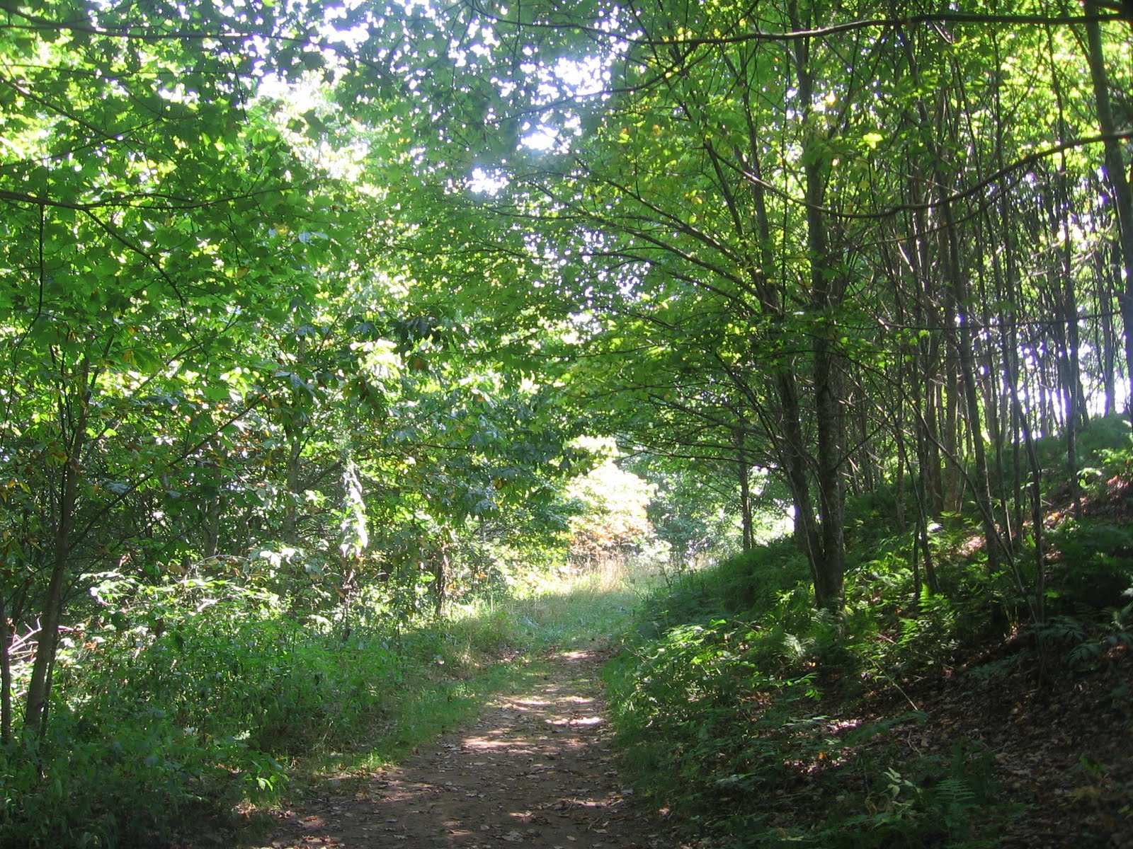
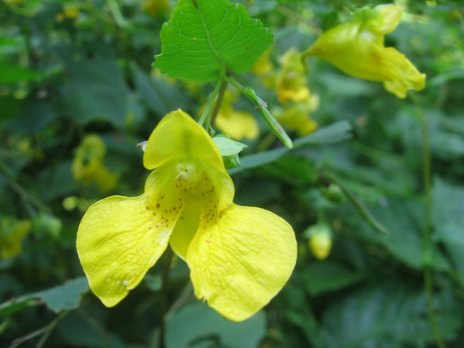
The trail entered a patch of woods and the shade felt good after the open sun on the main part of the bald.  There were lots of yellow and orange touch-me-nots.  Near a spring and the remains of an old spring house there was a critter scolding us although we never spotted him.  The trail appears to become and old road for part of this section.

The trail comes out of the woods just a short distance from the parking and to the left of the trail that we went up on.  I was actually surprised how quickly we were back.  This was a fun area with great views for a minimum effort.  We headed back down the long gravel road and back toward Hot Springs for lunch in one of the local restaurants.

After a relaxed lunch we looked for the Silver Mine trail head.  To get there we went over the bridge, took an almost immediate left, then left again to cross under the main road.  The parking is up the gravel road from the trail at the entrance to the group camping area.  We parked and walked a short distance back to where the Appalachian Trail follows the French Broad river. 

The trail follows the river for about a half mile.  Near the start of the trail was a high rock formation.  We were to see these rocks again from part way up and a third time at the top.  But for now we were just enjoying the view of the river.  There were camp sites on the opposite bank and people playing in the water.  This easy stroll was to end suddenly just ahead.

The trail switchs back and quickly climbs the ridge that had been paralleling us.  The trail is narrow and out in the open sun.  A wrong step would be a long way down.  We began to hear thunder approaching in the distance.  When we reached the rocks we had seen below there was another switch back and we climbed higher.  A third switch back led to the top of the rocks.

From here we had a great view of the river and the town beyond.  We believed this was the top and that our connecting trail was just ahead.  The thunder was getting closer so we quickly moved on.  The trail continued to climb to a higher view point then curved around the end of the ridge.  This is only a 1.6 mile loop hike but with the storm approaching and the steep climb it felt longer.

Finally we reached the intersection where the Lovers Leap trail leads back down.  The trail enters the woods as it switchbacks down.  The shade and breeze ahead of the storm made this part of the hike much more pleasant.  It was still steep and narrow but not such a sharp drop off on the side.  The final section was a level woods walk along a creek to the parking.

I would recomment Max Patch for a hike with children.  There is lots of room for them to explore.  They would also enjoy walking along the river but I would be very cautious about the trail going up to Lovers Leap.  We will return to this area to camp and explore more of the many available trails.

Sunday, August 21, 2011

Black Balsam Knob and Tennent Mountain 8/20/2011

We headed out to the Black Balsam area hoping to pick lots of blueberries.  The trail head area is off of the Blue Ridge Parkway north of mm 420.  The parking lot is about a mile off of the parkway.  There is also room to park along the access road where the Art Loeb Trail crosses.  We parked beside the road and entered the woods on the Art Loeb Trail.

We found a few blackberries on the bushes along the first section of the trail.  It is quickly obvious that this trail is eroded.  After a short walk in the balsam woods we came out in the open and passed the lone tree shown above.  From here the walk is  uphill through grassy areas and over rocks.  There are soon wide open vistas in all directions.

We topped the first rise and walked level for a few minutes before turning right and climbing to the top of Black Balsam Knob.  We could see Sam Knob that we climbed earlier this year to the left and Looking Glass Rock to the right.  The last part of the climb is a lot like a steep dry river bed with lots of rock but this section is short.  At the top is a plaque about Art Loeb in a great spot to sit and enjoy the view.
From this point it is a level walk along the top of the knob before heading downhill through lots of blueberry bushes.  Last year we easily picked about a gallon of blueberries.  This year there were no blueberries in sight.  It appears this year's crop was destroyed by Spring hail storms.  The trail down the backside of the knob is narrow and very eroded in places.

Once we reached the saddle and began to climb Tennent mountain the trail became more open.  There were low berry bushes and great views.  We stopped for a break when we reached the ridge and I got a picture of this butterfly who matched the rock colors pretty well.  As we walked along the ridge we could see storm clouds building over the mountains.

At the far end of the ridge the trail switchbacks and heads down the backside of Tennent.  Once again we were in taller bushes and the trail was eroded.  We were surprised to see a pickup truck in the next saddle area ahead.  Before long we were down into another saddle where the Art Loeb Trail and the Ivestor Trail meet for the first time.

The Ivestor Gap Trail is a road bed that is very rocky.  It is open to vehicles for a part of the year and there was in fact a pickup truck at this point.  This road would require four wheel drive and high clearance.  We turned left and headed back toward the parking area.  The trail was shaded and damp with several springs coming off of Black Balsam Knob on the left.

This trail followed around the knob rather then climbing it and although it was not totally level it was a pleasant way to finish our hike.  There were flowers blooming along the trail.  We passed several backpack campsites.  The views weren't as open as on top of the balds but they were still there.  After a hike of about four miles we were ready to see the parking lot.

We made a stop at the chemical toilet facilities in the parking lot before beginning the last half mile up the road to where we had parked.  The storm finally broke while we were in the parking lot and even with the emergency ponchos we were soaked by the time we reached the van.  This was a fun hike.  The trails were busy with lots of people backpacking, day hiking with children or dogs,and there was even a pot belly pig on a leash.