It is Spring with the Azaleas in full bloom and the leaves on the trees at home in Shelby but up here over a mile above sea level it still looks like winter. This trail head is at the end of Black balsam Road at around mile marker 420 on the Blue Ridge Parkway. When we arrived about 9 a.m. the parking lot was almost full but there are enough trails here that it doesn't feel crowded.
We started out on the trail past the gate to the left of the restrooms. The trail is blue blazed and there is a blaze on a rock at the start but we only saw a few blazes along the trail. The first half mile or so is along a grassy area and across a meadow. The bluets and dandelions are just starting to appear. This meadow should be beautiful in a week or two.
At the far side of the meadow signs indicate a right turn for San Knob and a left to Laurel Creek. We turned right and begin a steady but not too steep climb to the top of Sam Knob. The first section is wooded but after a short flight of steps it becomes more open with great views. Just below the stairs is a muddy area where you can see a spring coming out of the hill.
Beyond the stairs there are areas where the trail is narrow with a steep drop off on one side and a steep hill on the other. There are rocks to negotiate but nothing too difficult. You can hear and see Laurel Creek far below and view Devil's Courthouse in the distance. As you near the top the trail forks. The left fork takes you to the slightly higher peak but you will want to visit both.
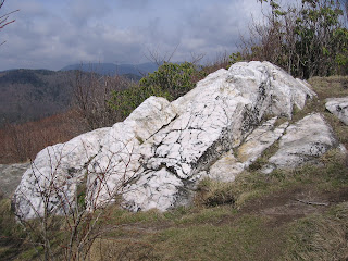
To the left is a very large quartz rock and great views to the north. We watched a pair of Towhees play on the rocks and looked at Highway 215 winding its way down into the valley. We found the geocache that has been hiding up here for about ten years. Then we backtracked a few hundred feet and took the other short trail to enjoy more views before heading back down.
We headed back down to the trail junction only seeing two other couples the whole time on the knob trail. If we headed back the way we came the hike would be 2.2 miles total but we wanted a longer loop hike so we turned toward Laurel Creek. The connector trail is a gentle downhill that would be quite wet in spots if there weren't a series of short boardwalks.
The trail crosses a small tributary before reaching Laurel Creek. We knew we were approaching the creek by the line of trees ahead. There was about fifty feet of mud to cross right before the creek. To reach the Flat Laurel Creek trail we had to cross Laurel Creek. With a little planning and a long step or two we were able to cross without getting our feet wet.
We turned left and headed back toward the trail head. We could have turned right and followed the trail farther along the creek. Up stream a short distance we found a campsite by a pretty spot in the creek and had our picnic lunch. There are several nice primitive hike in campsites along these trails A towhee stopped by to see if we would share our lunch with him.
Soon the trail began to gently climb uphill and away from the creek. We could still hear the creek and occasionally see it. At times the trail is wide and at times it narrows. There are numerous crossing of small runs and at times the water runs right down the trail. The bottoms of our hiking boots got wet but that was all.
This trail climbs to the top of the hill and makes a long circle around the valley below returning to the opposite end of the parking lot from where we started. In numerous places along this hike Pussy Willows were blooming. This is the first time I have seen them in bloom since growing up in Massachusetts. This approximately four mile hike was very pleasant with lots of variety without a lot of difficulty.


 This hike begins at the Bad Creek Trail Head on the property of the Duke Power's Bad Creek Hydroelectric Station property. There is a large parking area and portable toilets. The trail passes through a young grove of trees before climbing up, around, and down the other side of a wooded hill. This trail is not overly difficult but is not stroller friendly. As we rounded the hill we could hear the river down below.
 At the bottom of the hill we walked through a level area and began to see wildflowers, ferns, and other ground covers. Soon we were crossing the river at the twin bridges. The trail ends at the intersection with the Foothills trail. This location as with all the intersections on this hike is well signed. We made a right turn and continued across the valley area.
 After following a small run for a short distance the trail climbs away from the river. There are wildflowers scattered all along the trail. We saw seven other hikers total on the trail today. There is much less traffic on this trail then at Upper Whitewater falls. We wondered why we weren't following closer to the river but once we reached the falls overlook we understood the need to go around the gorge.
 At the next trail intersection we turned right on the spur trail to the falls overlook. The trail goes through the woods, joins a gravel road for a short distance, then turns right off of the road. If you pay attention to the signs and blazes it isn't hard to follow. There is a short climb followed by the final steeper downhill to the overlook. The view from the overlook is fantastic and worth the effort to get there.
 How long is this hike? The sign at the parking area says 1.7 miles to the overlook. The sign at the overlook says 1.9 miles back to the trail head. The signs at the Foothills Trail and the spur trail add up to 2.4 miles one way. This sign by the twin bridges agrees that this is a 4.8 mile round trip hike. We wonder if this trail has been rerouted at some time.


 To the left is a very large quartz rock and great views to the north. We watched a pair of Towhees play on the rocks and looked at Highway 215 winding its way down into the valley. We found the geocache that has been hiding up here for about ten years. Then we backtracked a few hundred feet and took the other short trail to enjoy more views before heading back down.


